Temporary Flight Restrictions
Background
Temporary Flight Restrictions (TFRs) are a subset of Notices to Air Missions (NOTAMs). The purpose of NOTAMs are to “distribute information regarding unanticipated or temporary changes to services, components of, or hazards in, the National Airspace System”. TFRs are used by the FAA to restrict flight operations within designated areas, and are issued for a variety of reasons such as:
- protecting aircraft from surface-based hazards such as toxic gas spills or volcanic eruptions
- restricting overflights through certain airspace for reasons of national security
- providing a safe environment for the operation of disaster relief aircraft, e.g. firefighting activities, avalanche control, and search/rescue missions
- separating “non-participating” aircraft from those engaged in law enforcement operations
- protection of persons or property on the surface and preventing unsafe aerial congestion in the vicinity of major sporting events or aerial demonstrations
TFRs are continually being published, changed, expired, and cancelled. In order to provide the most recent official information, when you query one of the DFlight API /restrictions endpoints we in turn retrieve the current TFRs in real time from the Federal NOTAM System (FNS).
{
  "poly":
  {
    "type": "Polygon",
    "coordinates": [[[-155.426425, 19.545118],[-155.59946, 19.440516],[-155.348422, 19.335847],[-155.426425, 19.545118]]]
  }
}
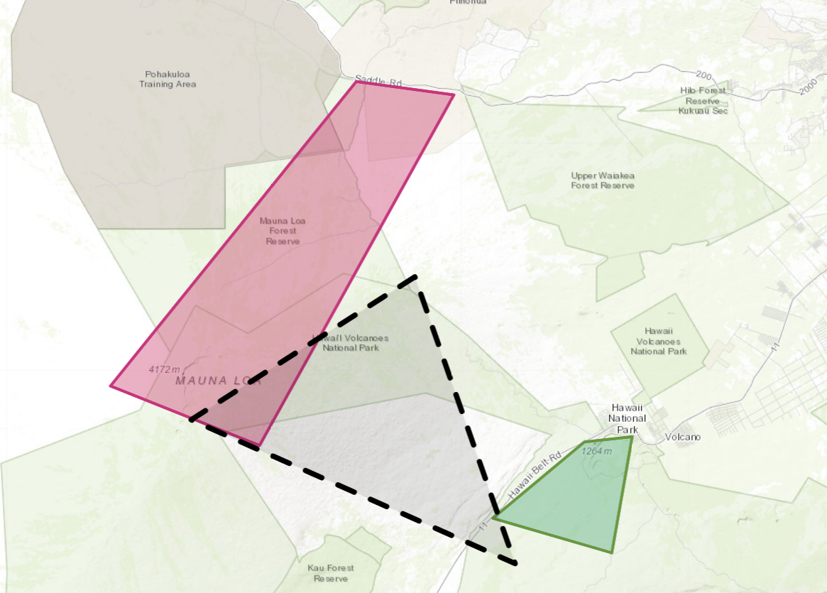
and we’ll send our POST request to the /restrictions/polygon-query endpoint.
As with all request types (except airspace), the response body is a json object containing a single element named found. The contents of found will be a GeoJSON FeatureCollection with one Feature per TFR found in the requested area of interest. Below shows our returned results, with the dashed outlined polygon indicating our requested area.
{
"found": {
"type": "FeatureCollection",
"features": [
{
"type": "Feature",
"geometry": {
"type": "GeometryCollection",
"geometries": [
{
"type": "Polygon",
"heightInformation": {
"upperLevel": "1500",
"uomUpperLevel": "FT",
"lowerLevel": "0",
"uomLowerLevel": "FT"
},
"coordinates": [
[
[
-155.295,
19.424444
],
[
-155.258333,
19.428611
],
[
-155.274167,
19.343611
],
[
-155.366111,
19.368889
],
[
-155.295,
19.424444
]
]
]
},
{
"type": "Polygon",
"heightInformation": {
"upperLevel": "1500",
"uomUpperLevel": "FT",
"lowerLevel": "0",
"uomLowerLevel": "FT"
},
"coordinates": [
[
[
-155.471389,
19.687222
],
[
-155.395833,
19.677778
],
[
-155.546389,
19.421667
],
[
-155.661944,
19.465
],
[
-155.471389,
19.687222
]
]
]
}
]
},
"properties": {
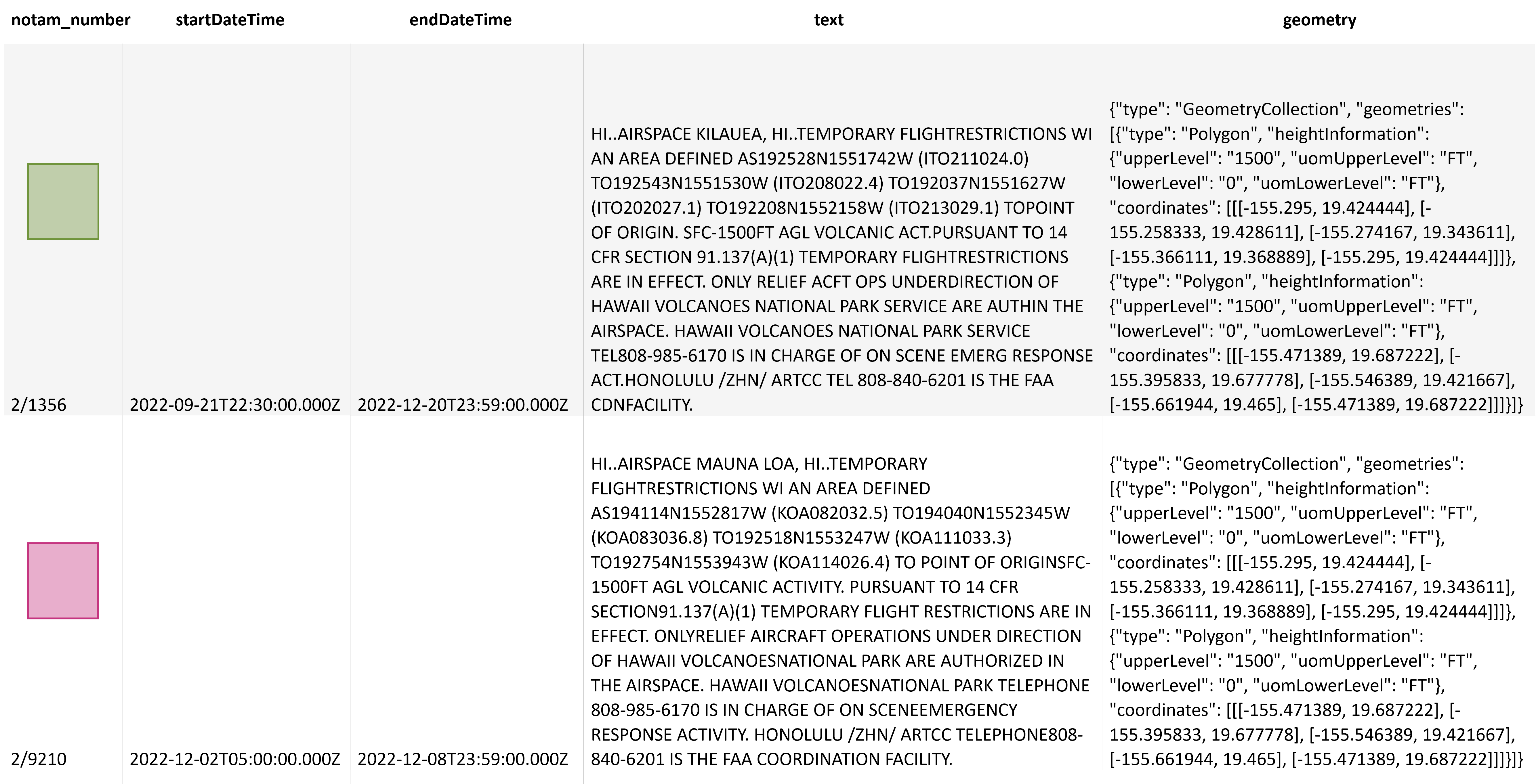
"notam_number": "2/1356",
"startDateTime": "2022-09-21T22:30:00.000Z",
"endDateTime": "2022-12-20T23:59:00.000Z",
"text": "HI..AIRSPACE KILAUEA, HI..TEMPORARY FLIGHTRESTRICTIONS WI AN AREA DEFINED AS192528N1551742W (ITO211024.0) TO192543N1551530W (ITO208022.4) TO192037N1551627W (ITO202027.1) TO192208N1552158W (ITO213029.1) TOPOINT OF ORIGIN. SFC-1500FT AGL VOLCANIC ACT.PURSUANT TO 14 CFR SECTION 91.137(A)(1) TEMPORARY FLIGHTRESTRICTIONS ARE IN EFFECT. ONLY RELIEF ACFT OPS UNDERDIRECTION OF HAWAII VOLCANOES NATIONAL PARK SERVICE ARE AUTHIN THE AIRSPACE. HAWAII VOLCANOES NATIONAL PARK SERVICE TEL808-985-6170 IS IN CHARGE OF ON SCENE EMERG RESPONSE ACT.HONOLULU /ZHN/ ARTCC TEL 808-840-6201 IS THE FAA CDNFACILITY."
}
},
{
"type": "Feature",
"geometry": {
"type": "GeometryCollection",
"geometries": [
{
"type": "Polygon",
"heightInformation": {
"upperLevel": "1500",
"uomUpperLevel": "FT",
"lowerLevel": "0",
"uomLowerLevel": "FT"
},
"coordinates": [
[
[
-155.295,
19.424444
],
[
-155.258333,
19.428611
],
[
-155.274167,
19.343611
],
[
-155.366111,
19.368889
],
[
-155.295,
19.424444
]
]
]
},
{
"type": "Polygon",
"heightInformation": {
"upperLevel": "1500",
"uomUpperLevel": "FT",
"lowerLevel": "0",
"uomLowerLevel": "FT"
},
"coordinates": [
[
[
-155.471389,
19.687222
],
[
-155.395833,
19.677778
],
[
-155.546389,
19.421667
],
[
-155.661944,
19.465
],
[
-155.471389,
19.687222
]
]
]
}
]
},
"properties": {
"notam_number": "2/9210",
"startDateTime": "2022-12-02T05:00:00.000Z",
"endDateTime": "2022-12-08T23:59:00.000Z",
"text": "HI..AIRSPACE MAUNA LOA, HI..TEMPORARY FLIGHTRESTRICTIONS WI AN AREA DEFINED AS194114N1552817W (KOA082032.5) TO194040N1552345W (KOA083036.8) TO192518N1553247W (KOA111033.3) TO192754N1553943W (KOA114026.4) TO POINT OF ORIGINSFC-1500FT AGL VOLCANIC ACTIVITY. PURSUANT TO 14 CFR SECTION91.137(A)(1) TEMPORARY FLIGHT RESTRICTIONS ARE IN EFFECT. ONLYRELIEF AIRCRAFT OPERATIONS UNDER DIRECTION OF HAWAII VOLCANOESNATIONAL PARK ARE AUTHORIZED IN THE AIRSPACE. HAWAII VOLCANOESNATIONAL PARK TELEPHONE 808-985-6170 IS IN CHARGE OF ON SCENEEMERGENCY RESPONSE ACTIVITY. HONOLULU /ZHN/ ARTCC TELEPHONE808-840-6201 IS THE FAA COORDINATION FACILITY."
}
}
]
}
}
The feature properties given for restrictions are:
- notam_number: composed as year-of-issuance/serial-number (only last digit of the year)
- startDateTime: day/time when restriction starts
- endDateTime: day/time when the restriction ends
- text: will include the purpose or reason for the restriction, textual description of the area impacted, and the FAA coordination facility telephone number
Be aware of the following conventions applicable to TFRs:
- Multiple areas may be specified in one TFR when the areas are in the same ARTCC airspace
- A separate TFR will be given for each effective period when there are multiple
- The impacted altitudes are included in the Geometry element of the GeoJSON feature as heightInformation
Given that a single TFR can apply to multiple separate areas, the GeoJSON type used for all geometries will be a GeometryCollection (even if it contains only a single item in the “geometries” list).