Aerodromes
Background
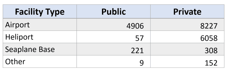
The term aerodrome encompasses airports, heliports, seaplane bases, and facilities designated for use by another specific type of aircraft such as sailplanes, ultralights, or hot air balloons. Small privately-owned aerodromes vastly outnumber public facilities:
Fewer than 5% of aerodromes are associated with controlled (Class B, C, D, or E2) airspace, meaning prior authorization is not needed to operate near many of these facilities. But UAS operators are required to be aware of their presence and be prepared to avoid conflict and yield right of way to any manned aircraft.
The Aerodromes endpoints
Request bodies for /aerodromes endpoints are “basic”, meaning the only information you need to provide are those parameters that define your area of interest (point/distance, route, or poly).
In all cases, the response body will be a json object containing a single element named found. The contents of found will be a GeoJSON FeatureCollection with one Feature per aerodrome found in your requested area of interest. The feature properties given for aerodromes are:
- ident: FAA site identifier
- name: facility name
- facility_type:
- PRIVATE AIRPORT
- PRIVATE BALLOONPORT
- PRIVATE GLIDERPORT
- PRIVATE HELIPORT
- PRIVATE SEAPLANE BASE
- PRIVATE ULTRALIGHT
- PUBLIC AIRPORT
- PUBLIC BALLOONPORT
- PUBLIC GLIDERPORT
- PUBLIC HELIPORT
- PUBLIC SEAPLANE BASE
- PUBLIC ULTRALIGHT
- facility_status:
- OPERATIONAL
- CLOSED INDEFINITELY
- CLOSED PERMANENTLY
The geometry type of Features returned from /aerodromes endpoints will always be a single Point, usually the centroid of the facility’s property but it could be anywhere within the bounds of the facility. Keep this in mind when interpreting your results and also that:
- the greatest potential for conflict is generally when manned aircraft are arriving (descending to) or departing (climbing out from) the aerodrome, i.e. when they will be at the same altitudes as traversing UAVs
- climb and descent profiles for manned aircraft will differ by type (airplane, helicopter, seaplane, glider, or balloon)
- distance and polygon queries return only the the aerodromes whose point coordinates are contained within – or intersect the boundaries of – your requested area
- route queries return all aerodromes within 1 nautical mile of your route
Below are examples of each request type.
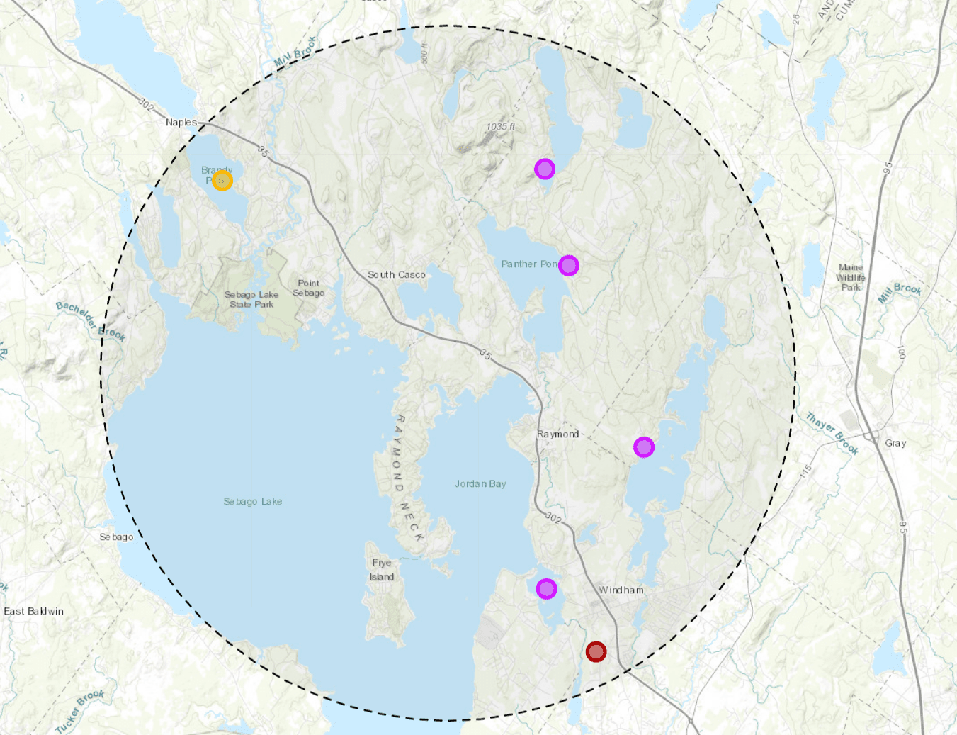
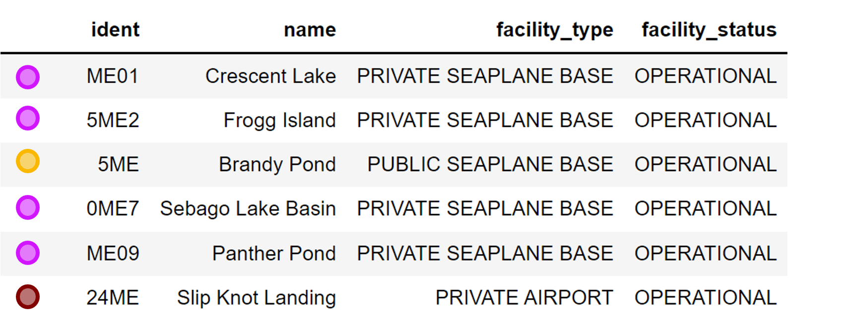
Distance Request
- Request body:
{ "longitude": -70.5, "latitude": 43.9, "distance": 15000 } - Endpoint: https://dflight-api.ljaero.com/us/v1/aerodromes/distance-query
{
  "found": {
    "type": "FeatureCollection",
    "features": [
      {
        "type": "Feature",
        "geometry": {
          "type": "Point",
          "coordinates": [
            -70.462555,
            43.957016
          ]
        },
        "properties": {
          "ident": "ME01",
          "name": "Crescent Lake",
          "facility_type": "PRIVATE SEAPLANE BASE",
          "facility_status": "OPERATIONAL"
        }
      },
      {
        "type": "Feature",
        "geometry": {
          "type": "Point",
          "coordinates": [
            -70.424165,
            43.879443
          ]
        },
        "properties": {
          "ident": "5ME2",
          "name": "Frogg Island",
          "facility_type": "PRIVATE SEAPLANE BASE",
          "facility_status": "OPERATIONAL"
        }
      },
      {
        "type": "Feature",
        "geometry": {
          "type": "Point",
          "coordinates": [
            -70.587471,
            43.953887
          ]
        },
        "properties": {
          "ident": "5ME",
          "name": "Brandy Pond",
          "facility_type": "PUBLIC SEAPLANE BASE",
          "facility_status": "OPERATIONAL"
        }
      },
      {
        "type": "Feature",
        "geometry": {
          "type": "Point",
          "coordinates": [
            -70.462015,
            43.839715
          ]
        },
        "properties": {
          "ident": "0ME7",
          "name": "Sebago Lake Basin",
          "facility_type": "PRIVATE SEAPLANE BASE",
          "facility_status": "OPERATIONAL"
        }
      },
      {
        "type": "Feature",
        "geometry": {
          "type": "Point",
          "coordinates": [
            -70.45311,
            43.930072
          ]
        },
        "properties": {
          "ident": "ME09",
          "name": "Panther Pond",
          "facility_type": "PRIVATE SEAPLANE BASE",
          "facility_status": "OPERATIONAL"
        }
      },
      {
        "type": "Feature",
        "geometry": {
          "type": "Point",
          "coordinates": [
            -70.442776,
            43.822221
          ]
        },
        "properties": {
          "ident": "24ME",
          "name": "Slip Knot Landing",
          "facility_type": "PRIVATE AIRPORT",
          "facility_status": "OPERATIONAL"
        }
      }
    ]
  }
} 
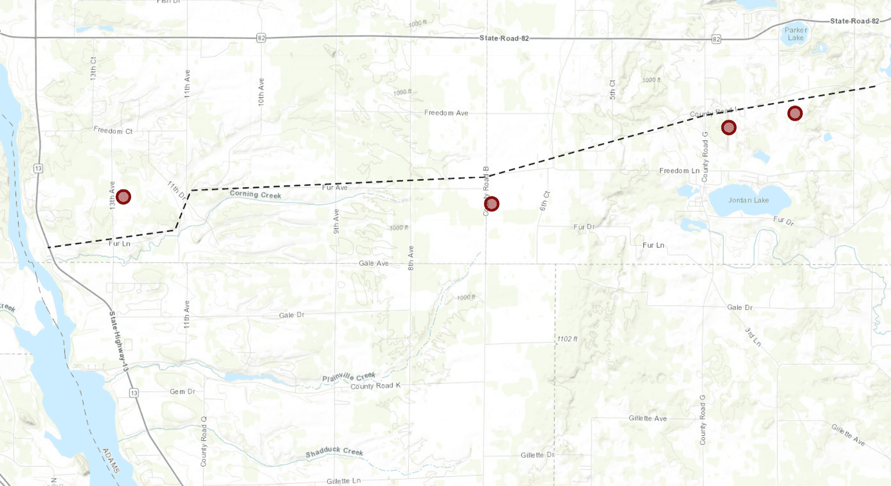
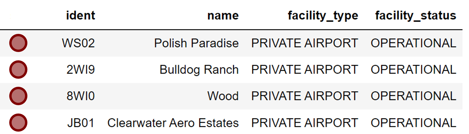
Route Request
- Request body:
{ "route": { "type": "LineString", "coordinates": [ [-89.613, 43.765], [-89.658, 43.759], [-89.7, 43.751], [-89.717, 43.747], [-89.796, 43.745], [-89.8, 43.737], [-89.834, 43.734] ] } } - Endpoint: https://dflight-api.ljaero.com/us/v1/aerodromes/route-query
{
  "found": {
    "type": "FeatureCollection",
    "features": [
      {
        "type": "Feature",
        "geometry": {
          "type": "Point",
          "coordinates": [
            -89.715957,
            43.742477
          ]
        },
        "properties": {
          "ident": "WS02",
          "name": "Polish Paradise",
          "facility_type": "PRIVATE AIRPORT",
          "facility_status": "OPERATIONAL"
        }
      },
      {
        "type": "Feature",
        "geometry": {
          "type": "Point",
          "coordinates": [
            -89.634845,
            43.759977
          ]
        },
        "properties": {
          "ident": "2WI9",
          "name": "Bulldog Ranch",
          "facility_type": "PRIVATE AIRPORT",
          "facility_status": "OPERATIONAL"
        }
      },
      {
        "type": "Feature",
        "geometry": {
          "type": "Point",
          "coordinates": [
            -89.814291,
            43.743866
          ]
        },
        "properties": {
          "ident": "8WI0",
          "name": "Wood",
          "facility_type": "PRIVATE AIRPORT",
          "facility_status": "OPERATIONAL"
        }
      },
      {
        "type": "Feature",
        "geometry": {
          "type": "Point",
          "coordinates": [
            -89.652623,
            43.7572
          ]
        },
        "properties": {
          "ident": "JB01",
          "name": "Clearwater Aero Estates",
          "facility_type": "PRIVATE AIRPORT",
          "facility_status": "OPERATIONAL"
        }
      }
    ]
  }
} 
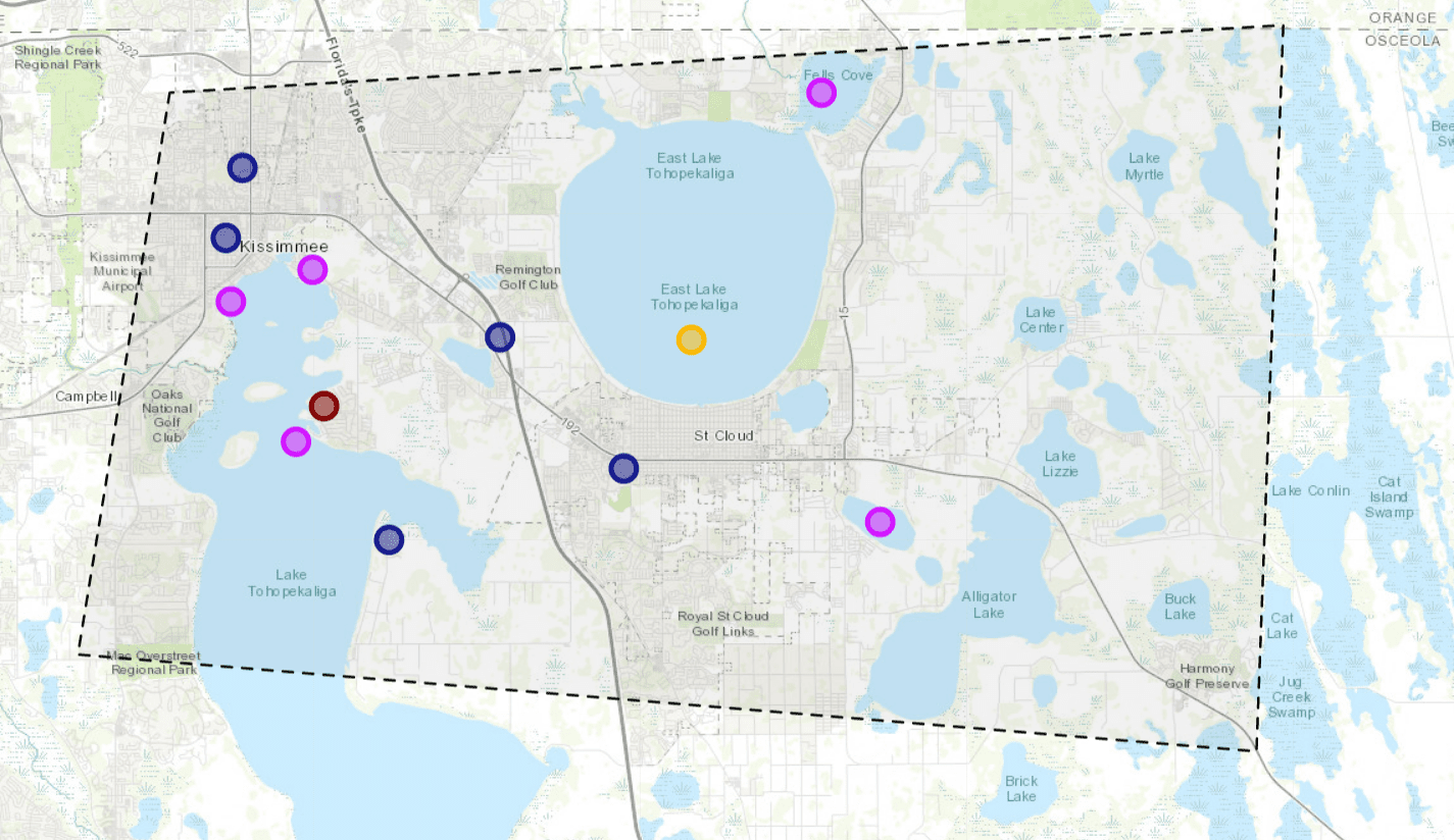
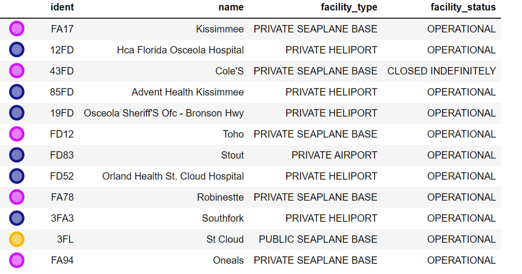
Polygon Request
- Request body:
{ "poly": { "type": "Polygon", "coordinates": [[ [-81.425,28.333], [-81.450,28.199], [-81.133,28.176], [-81.125,28.349], [-81.425,28.333] ]] } } - Endpoint: https://dflight-api.ljaero.com/us/v1/aerodromes/polygon-query
{
  "found": {
    "type": "FeatureCollection",
    "features": [
      {
        "type": "Feature",
        "geometry": {
          "type": "Point",
          "coordinates": [
            -81.408955,
            28.28362
          ]
        },
        "properties": {
          "ident": "FA17",
          "name": "Kissimmee",
          "facility_type": "PRIVATE SEAPLANE BASE",
          "facility_status": "OPERATIONAL"
        }
      },
      {
        "type": "Feature",
        "geometry": {
          "type": "Point",
          "coordinates": [
            -81.410242,
            28.298534
          ]
        },
        "properties": {
          "ident": "12FD",
          "name": "Hca Florida Osceola Hospital",
          "facility_type": "PRIVATE HELIPORT",
          "facility_status": "OPERATIONAL"
        }
      },
      {
        "type": "Feature",
        "geometry": {
          "type": "Point",
          "coordinates": [
            -81.387218,
            28.291109
          ]
        },
        "properties": {
          "ident": "43FD",
          "name": "Cole'S",
          "facility_type": "PRIVATE SEAPLANE BASE",
          "facility_status": "CLOSED INDEFINITELY"
        }
      },
      {
        "type": "Feature",
        "geometry": {
          "type": "Point",
          "coordinates": [
            -81.405899,
            28.315286
          ]
        },
        "properties": {
          "ident": "85FD",
          "name": "Advent Health Kissimmee",
          "facility_type": "PRIVATE HELIPORT",
          "facility_status": "OPERATIONAL"
        }
      },
      {
        "type": "Feature",
        "geometry": {
          "type": "Point",
          "coordinates": [
            -81.336495,
            28.275098
          ]
        },
        "properties": {
          "ident": "19FD",
          "name": "Osceola Sheriff'S Ofc - Bronson Hwy",
          "facility_type": "PRIVATE HELIPORT",
          "facility_status": "OPERATIONAL"
        }
      },
      {
        "type": "Feature",
        "geometry": {
          "type": "Point",
          "coordinates": [
            -81.391455,
            28.250288
          ]
        },
        "properties": {
          "ident": "FD12",
          "name": "Toho",
          "facility_type": "PRIVATE SEAPLANE BASE",
          "facility_status": "OPERATIONAL"
        }
      },
      {
        "type": "Feature",
        "geometry": {
          "type": "Point",
          "coordinates": [
            -81.383955,
            28.258621
          ]
        },
        "properties": {
          "ident": "FD83",
          "name": "Stout",
          "facility_type": "PRIVATE AIRPORT",
          "facility_status": "OPERATIONAL"
        }
      },
      {
        "type": "Feature",
        "geometry": {
          "type": "Point",
          "coordinates": [
            -81.303443,
            28.243901
          ]
        },
        "properties": {
          "ident": "FD52",
          "name": "Orland Health St. Cloud Hospital",
          "facility_type": "PRIVATE HELIPORT",
          "facility_status": "OPERATIONAL"
        }
      },
      {
        "type": "Feature",
        "geometry": {
          "type": "Point",
          "coordinates": [
            -81.249996,
            28.332998
          ]
        },
        "properties": {
          "ident": "FA78",
          "name": "Robinestte",
          "facility_type": "PRIVATE SEAPLANE BASE",
          "facility_status": "OPERATIONAL"
        }
      },
      {
        "type": "Feature",
        "geometry": {
          "type": "Point",
          "coordinates": [
            -81.366523,
            28.226942
          ]
        },
        "properties": {
          "ident": "3FA3",
          "name": "Southfork",
          "facility_type": "PRIVATE HELIPORT",
          "facility_status": "OPERATIONAL"
        }
      },
      {
        "type": "Feature",
        "geometry": {
          "type": "Point",
          "coordinates": [
            -81.28499,
            28.274348
          ]
        },
        "properties": {
          "ident": "3FL",
          "name": "St Cloud",
          "facility_type": "PUBLIC SEAPLANE BASE",
          "facility_status": "OPERATIONAL"
        }
      },
      {
        "type": "Feature",
        "geometry": {
          "type": "Point",
          "coordinates": [
            -81.23444,
            28.231109
          ]
        },
        "properties": {
          "ident": "FA94",
          "name": "Oneals",
          "facility_type": "PRIVATE SEAPLANE BASE",
          "facility_status": "OPERATIONAL"
        }
      }
    ]
  }
}